Collect. Understand. Plan. Act.
We provide public and private organisations with the software solutions, tools, information and means to effectively take action in their operating environments, attaining and maintaining decisive competitive advantage.

Operations Management
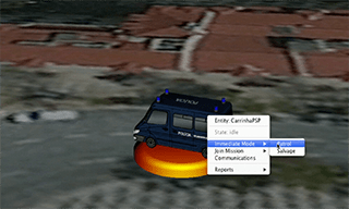
Distributed asset management solutions ranging from local logistics, dispatch and courier companies to nation-wide State agents with complex C4ISR Military Command and Control requirements.

Monitoring and Surveillance
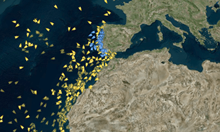
Flexible real time scenario analysis solutions ranging from crowd management and theft control in public events to 24/7 large area monitoring and surveillance with active multi-target tracking.

Environmental Modelling
Geospatial Modelling solutions addressing natural or human-made events and their environmental contribution for researchers, policy makers and economic agent compliance regulators.

Geospatial Intelligence
Real-time or Deferred geospatial business intelligence information solutions for agile, competitive decision making and operational support.
Our Core Technology
Inovaworks builds and licenses its flagship product GeoC2 - a comprehensive 4D geographic information system that helps decision-makers to monitor, analyze, process and control an organisation’s distributed assets.

Visualize
Create comprehensive Situational Awareness
GeoC2 allows organisations to ingest and process massive amounts of real-time data and consolidate ongoing events into a comprehensive timeline that can be further processed or visualised on our powerful web-based toolchain.

Understand
Extract Relevance from Chaos
GeoC2 processes incoming data flows in both deferred and in real-time, building sophisticated analysis and complex correlations with valuable insights from massive datasets.

Plan
Maintain critical Best Practices under operational stress
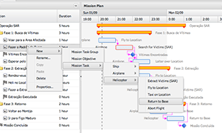
GeoC2 allows organisations to deploy operational assets in pre-built, doctrine-compliant mission plans, or to quickly adapt to volatile situations in ad-hoc goal-driven planning augmented with over-the-shoulder automated advice.

Act
A small tagline
Execute and Monitor simple to complex distributed endeavours, continuously adjusting mission outcomes and proposing corrective actions as the plan's execution evolves.
What We Do

NIPIM@R ShippingIntelligenceNetwork
Member States authorities carry out a large number of different operational surveillance tasks, many of them to fulfil obligations imposed by EU legislation, the aim of which is to ensure the safety and protection of our seas and oceans. The ambition of all those involved in operational surveillance activities is to have timely access to relevant and most accurate information to carry out their work and exchange information seamlessly between their systems, patrolling and surveillance such as ships, planes, satellites, etc..
It is in this context that the "Portal de Informação Estratégica para a Segurança Marítima Integrada do Shipping" emerges.
This platform, will enable shipowners with vessels registered with MAR, as well as national agents with management and intervention in the system - DGRM, Marinha, SIS, DGPM, RIM-MAR, for example, to access, in real time, geolocation, context of risk, energy and environmental performance, and certification status of ships registered in the International MAR Ship Register.